
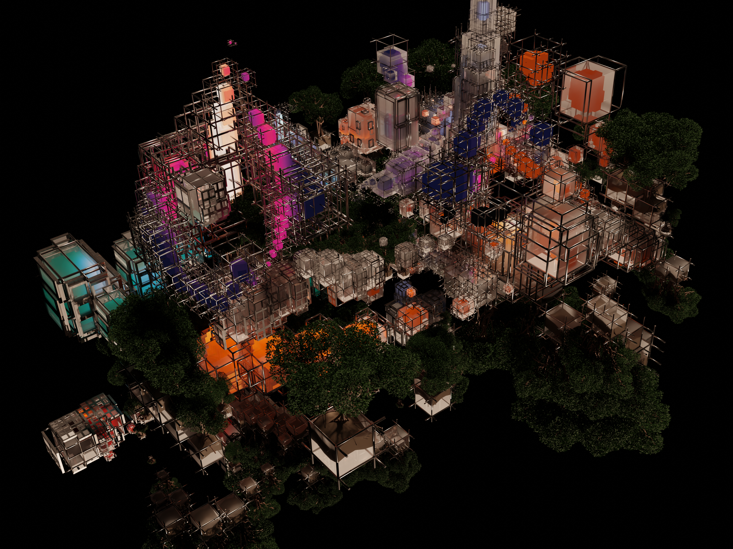
City in Aether
2023
Dimensions Variable
GPS Data
An ongoing study, exploring new paths, building new spaces
City in Aether, 2023
Dimensions VariableGPS Data
Future cities will be fast-paced and in constant flux. Cities are not just physical spaces, but a reflection of our collective culture and values. As the cities around us expand at unprecedented rates, how often do we pause, observe and reflect on the change that is constantly happening? We take the development of our urban landscape for granted even through, knowingly or unknowingly, we co-create what becomes of these spaces. From the patronage of places we frequent, to the feedback in unassuming surveys and the data collected and harvested from our devices. All these are contributing factors shape our future.
City in Aether is an abstract, cocreated interpretation of an ever-growing cityscape that is unpolished and in constant development. The work is not just a static object, but a living, breathing representation of the ever-evolving nature of cities and our experiences within them. Each “building” parametrically generated from personally collected and/or voluntarily contributed data (i.e. location, sound, light, etc.). As the data is collected by the participant(s), it also gives them an opportunity to reflect on the significance of where and what data is collected in the hope that they may develop a greater sensitivity to their surroundings.
City of Light aims to challenge our perceptions of what a city can be through collective lived interaction with our current built environments, sparking conversations about the role of technology and urban planning as we collectively shape our future cities.
Detail:


Press release:
Join the Path Project Exploration
"Record your journey digitally to, from or around a place of personal significance.
Take at least 15 minutes for the walk."
Join Wan Kyn's project by recording a 15-minute walk to, from or around a place that holds personal significance for you, using an app like Strava (Android or iPhone). It could be as simple as your daily commute, a nostalgic walk or a new exploration. Share the data from your walk with Wan Kyn and become part of his prizewinning concept that saw him crowned one of six winners of the Julius Baer Next Generation Art Prize.
The collected GPS data will be used to co-create digitally generated virtual cities and cityscapes as part of the ongoing Path Project, which explores the intangible elements that connect us to our environments. For more information on the project and previous works, visit Luminous Landscapes. (He recommends that you also take a photo along the way and submit it below. You may also want to record other things, such as sounds, along your walk.)
Take a walk in a place of personal significance.
Explore places you may have always wanted to visit.
Look at familiar environments through a different lens.
And share your experience.
For more information on how you can be involved and contribute, scroll down and contribute by clicking on the button below. The collection of contributions will be ongoing. Collections for the upcoming virtual exhibition for the Julius Baer Next Generation Art Prize have ended. New contributions are encouraged and will be used for subsequent iterations.
For Android:
1) Download Strava.
2) Record a walk that means something to you (Press "Record" when you want to start).
3) Select “Share”, 00 .
4) Select "More".
5) Select “Copy to Clipboard”. A link will be copied that can be shared.
6) Fill in the form here and share the copied link in the "Link to the route you have walked".
For iPhone:
1) Download Strava.
2) Record a walk that means something to you (Press "Record" when you want to start).
3) Click “Share”, 00 .
4) Select “Copy to Clipboard”. A link will be copied that can be shared.
5) Fill in the form here and share the copied link in the "Link to the route you have walked".


